

Dry, dry, dry. And on top of that, heat now, oppressive heat moving in today, into the Carolinas. Corey Davis is the Assistant State Climatologist for North Carolina. He knows all about this. Let’s start out with the dry conditions. First of all Corey, what are you seeing?
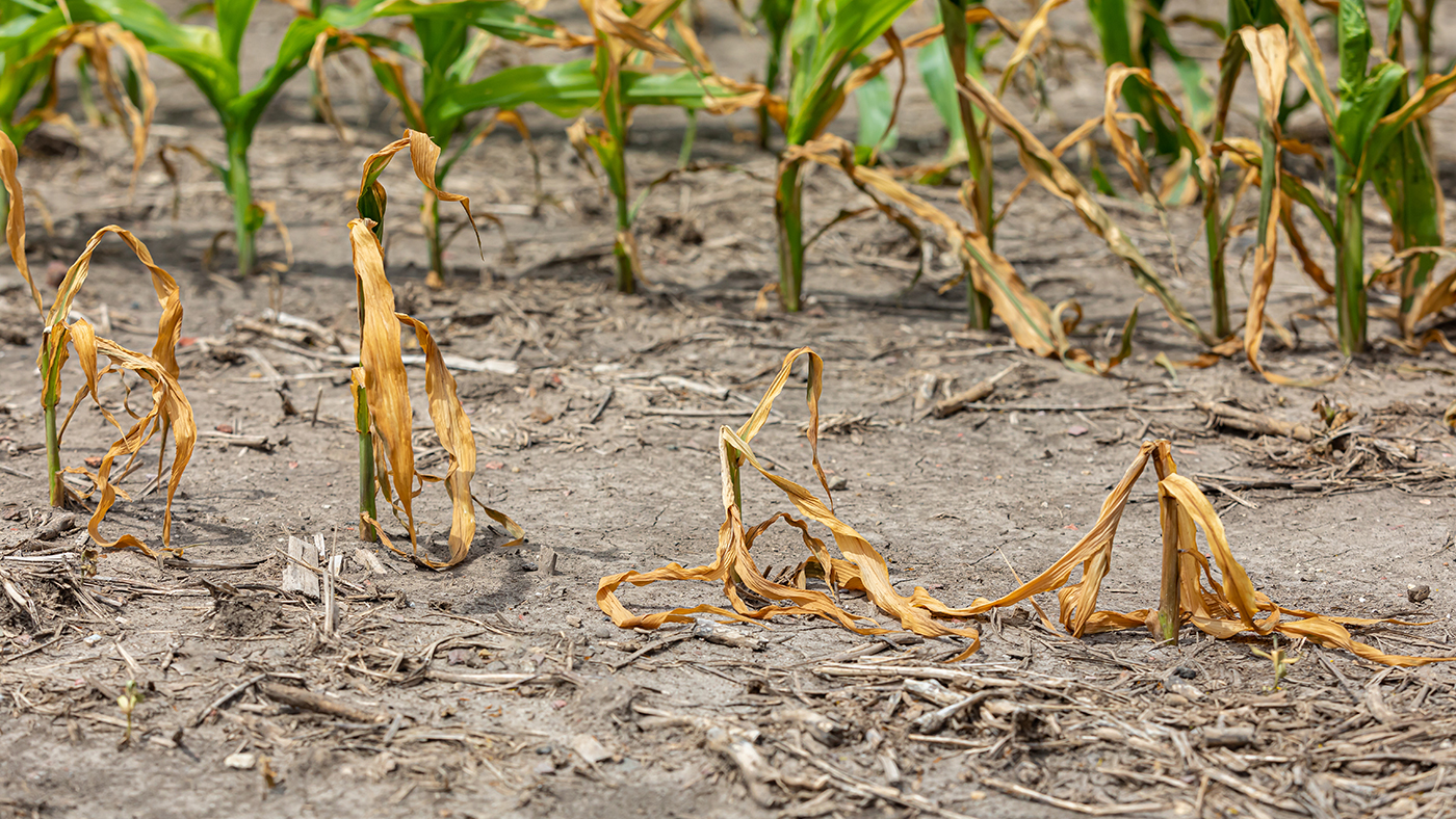
“Mike, summer has really slapped us in the face here. Over the last week or two, we went from being in pretty good shape coming out of May into June, especially for those farmers in their fields, to now seeing pretty widespread dry conditions and impacts emerging across the Carolinas this week. On the US Drought Monitor, we’ve got almost two thirds of North Carolina, it’s classified as abnormally dry. Now this is not technically in drought, and sometimes we never make it further than this abnormally dry classification, but in this case, with the trends that we’re seeing and with the forecast of more hot and dry weather on the way, it’s just a matter of time before we start seeing that drought returning across North Carolina, the main areas to watch for now are across the northern tier, right along the Virginia border, and then especially along our southern and central coastline. These are the places where we’ve seen the biggest precipitation deficits over the past month. Wilmington is now more than four inches below normal just in the last 30 days. And that’s also where we’re starting to see a lot of those soil moisture levels really drop. In this week on the USDA crop progress report for North Carolina, more than 60% of topsoil moisture was rated as short or very short, across the state, and then down in South Carolina, they’ve also seen an expansion of abnormally dry conditions and also the reintroduction of moderate drought for the first time since the very beginning of this year, we’re looking at parts of Berkeley County as seeing some of those dry conditions in the low country. And the reports we’re getting from the farmers there are saying that some of the cornfields may not be salvageable at this point. They’ve just been hit so hard by that combination of hot, dry weather in the last couple weeks, for farmers that are still trying to get crops planted, that planting is pretty much paused right now because there’s just so little soil moisture. So Mike, it has really dried out in a hurry. And especially feel for the farmers knowing the corn is going through tasseling into the silking phase, soybeans are starting to flower. This is not the time that those crops needed a dry spell.”
“Oh, absolutely not. And you mentioned in particular the coastal plain, low country, and in so many of those areas, that is sandy soil. So that only exacerbates the problem when you don’t have rain, right?
“That’s right, that soil is only going to hold on to so much moisture, that moisture will drain through pretty quickly. And now what we’ve seen just over the last two weeks is not only in the topsoil, but also in the subsoil. It really drying out in a hurry, and unfortunately, Mike, the forecast does not show a whole lot of relief in terms of rainfall or a break from this heat.”
Well, let’s talk about that forecast right now, and particularly as we look at today, some oppressive heat totals coming in. Where is that coming from? And what can we expect from it?
“Yeah, this is really a heat dome that’s building over our part of the country. There’s a surface high pressure system just off our coastline that is helping to push in some very warm and muggy air from the south. But also, we’re seeing upper level high pressure building across the southeast and the combination of those two high pressure systems, it’s just like throwing more blankets on top of us when we’re already hot. So we’re expecting high temperatures in the mid 90s today, upper 90s tomorrow. And Sunday looks like Sunday will be the hottest day in places like faithful that are usually a little bit warmer than their surroundings, have a shot at hitting 100 degrees on Sunday. This is not your garden variety summer heat. This is the sort of heat that we may only see once a year, again, very concerning to see temperatures this hot, especially for folks that are working outdoors. The other big concern is those overnight low temperatures, they are just not going to cool off this weekend. And looking at Sunday night, going into Monday, it may not drop below 75 degrees in most areas, and it is going to be very muggy, so again, pretty uncomfortable conditions all day long this weekend into early next week. And in terms of rainfall, there’s really only one chance of rain, and that’ll be on Monday, as a very weak front pushes through. We’ve backed off on the forecast of totals over the last week now only looking at maybe the quarter, half to half an inch of rain for most areas. So again, we don’t, don’t want to see a dry forecast like that, knowing how dry it’s already been. And certainly that seems like it is paving the way for more widespread drought across the Carolinas next week.”
As we look long term, how long do you anticipate this heat dome being over the Carolinas, and long term, any relief as far as rain past Sunday that you see right now?
“Well, the forecast from the Climate Prediction Center over the next eight to 14 days, so this is looking out into early July, is still showing a very high chance of above normal temperatures across our half of the country. So it doesn’t look like this pattern is really going to break anytime soon. In terms of precipitation, our best chances may come from the tropics, and we have seen some activity there over the last week. Earlier this week, we had the first name storm of the year, Tropical Storm Alberto. It made landfall yesterday in Mexico, there’s also a system just off the coast of Florida. Looks like it’ll be moving in around Florida or Georgia on during the day. Today, we probably won’t see much moisture from that system here in the Carolinas. But again, just seeing that activity beginning maybe gives us a little bit of hope that one of those systems could find its way in our neck of the woods.”